
CMORPH V1.0
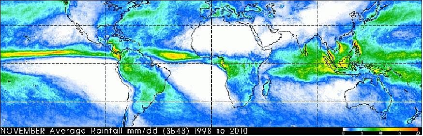
CMORPH (CPC MORPHing technique) produces global precipitation analyses at very high spatial and temporal resolution. This technique uses precipitation estimates that have been derived from low orbiter satellite microwave observations exclusively, and whose features are transported via spatial propagation information that is obtained entirely from geostationary satellite IR data. At present we incorporate precipitation estimates derived from the passive microwaves aboard the DMSP 13, 14 & 15 (SSM/I), the NOAA-15, 16, 17 & 18 (AMSU-B), and AMSR-E and TMI aboard NASA's Aqua and TRMM spacecraft, respectively. These estimates are generated by algorithms of Ferraro (1997) for SSM/I, Ferraro et al. (2000) for AMSU-B and Kummerow et al. (2001) for TMI. Note that this technique is not a precipitation estimation algorithm but a means by which estimates from existing microwave rainfall algorithms can be combined. Therefore, this method is extremely flexible such that any precipitation estimates from any microwave satellite source can be incorporated.
With regard to spatial resolution, although the preciptation estimates are available on a grid with a spacing of 8 km (at the equator), the resolution of the individual satellite-derived estimates is coarser than that - more on the order of 12 x 15 km or so. The finer "resolution" is obtained via interpolation.
In effect, IR data are used as a means to transport the microwave-derived precipitation features during periods when microwave data are not available at a location. Propagation vector matrices are produced by computing spatial lag correlations on successive images of geostationary satellite IR which are then used to propagate the microwave derived precipitation estimates. This process governs the movement of the precipitation features only. At a given location, the shape and intensity of the precipitation features in the intervening half hour periods between microwave scans are determined by performing a time-weighting interpolation between microwave-derived features that have been propagated forward in time from the previous microwave observation and those that have been propagated backward in time from the following microwave scan. We refer to this latter step as "morphing" of the features.
How to get the data
The CMORPH data can be accessed directly by clicking the highlighted links below. The data are stored in both high and low resolution forms. Rotating files that contain the most recent 31 days of:
30 minute estimates at ~ 8km resolution
3-hourly estimates at 1/4 x 1/4 degree lat/lon resolution
daily estimates at 1/4 x 1/4 degree lat/lon resolution
The entire CMORPH record (December 2002 - present) for 3-hourly, 1/4 degree lat/lon resolution can be found at 3-hourly, 1/4 x 1/4 degree
Because the CMORPH estimates are available about 18 hours pat real-time, users that require more timely estimates may be interested in "QMORPH" estimates, which are similar to CMORPH estimates, except that the passive microwave precipitation features are propagated via IR data forward in time only with no morphing. QMORPH estimates are available within 3 hours of real time, and the past 24 hours of QMORPH data are available at:
~8 km spatial resolution every 30 minutes at QMORPH 8km, 30 minute
1/4 degree lat/lon every 30 minutes at QMORPH 0.25 degree, 30 minute