GSMap
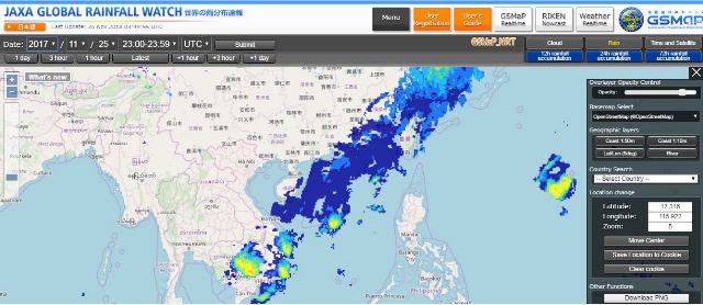
The Global Rainfall Watch published by the Japan Aerospace Exploration Agency (JAXA) is able to provide rainfall information on a quasi real-time basis, and on a global scale. This website takes rainfall and cloud cover data from several satellites that monitor these conditions. The Global Satellite Mapping of Precipitation (GSMap) is drawn up to the highest levels of precision and resolution in the world (Temporal resolution: 1 hour, Spatial resolution: Grid latitude-longitude of 0.1 degrees), and is published with an approximately 4-hour lag from the time of satellite monitoring (quasi real-time basis). There is also a rich store of information in its archives, and users who submit applications may retrieve long-term data sets for the 13-year period starting from March 2000. GSMaP data is used for research purposes such as the analysis of long-term data, for the verification of models by the Japan Meteorological Agency, and in flood prediction systems in developing countries and regions that do not have sufficient terrestrial hydrological information.

RESTEC is responsible for the operation of the Global Rainfall Watch system and for drawing up long-term data sets. It has established systems in order to ensure that the information can be published on a quasi real-time basis. These include the automatic retrieval of data from several satellites, the automation of a wide range of processes for computing rainfall, and error response systems. Furthermore, with the aim of improving visibility from the user’s point of view, efforts have been injected into improving visibility functions such as zooming in and out for regional and global display of the map, a superimposition function that allows users to display up to three types of data (rainfall, cloud cover, and satellite orbit) in layers as they wish, and the provision of 24-hour videos and Google Earth images.
Download: HERE


